Explore
Featured
Recent
Articles
Topics
Login
Upload
Featured
Recent
Articles
Topics
Login
Upload
Search Results for 'county map'
county map published presentations and documents on DocSlides.
Outline Map of Minnesota showing
by calandra-battersby
location of the County within the State. SHEET 1 O...
Public
by trish-goza
Hearings. June 16, 2015. Board of County Commissi...
Public
by tawny-fly
Hearings. September 22, 2015. Board of County Com...
Public Hearings
by ellena-manuel
September 15, 2015. Board of County Commissioners...
Public
by debby-jeon
Hearings. August 4, 2015. Board of County Commiss...
Surnames and Land Acquisition
by cheryl-pisano
Register of Deeds. 1792 Map of Robeson County (Bl...
Public
by calandra-battersby
Hearings. August 4, 2015. Board of County Commiss...
Public
by tatyana-admore
Hearings. January 13, 2015. Board of County Commi...
Shuming Bao
by pasty-toler
China Data Center. University of Michigan. Spatia...
TRAVEL PLANNER & WATERFALL MAP
by alexa-scheidler
TRANSYLVANIA COUNTY & BREVARD, NC TABLE OF CONTENT...
Phelps County R-3 “Slowly does it every time!” he said.
by jane-oiler
~Taken . from Aesop’s Fable the Tortoise and th...
1. Goals 2. Accomplishments
by adah
3. Plans. Biomass WG Breakout Report. • Connecti...
FLAMINGO ROADGRIFFIN ROADSHERIDAN STREETSTIRLING ROADPINE ISLAND
by delcy
06494202494201494205494203494204494205494104494103...
x0000x0000 xMCIxD 0 xMCIxD 0 Attachment
by melody
etermining Whether Youth are Living in a High Pove...
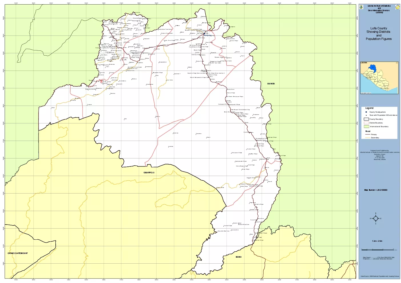
Popalahun
by barbara
WahBeduSoduKoduDopaGorluYealaBodahBiawuMamaiGombuK...
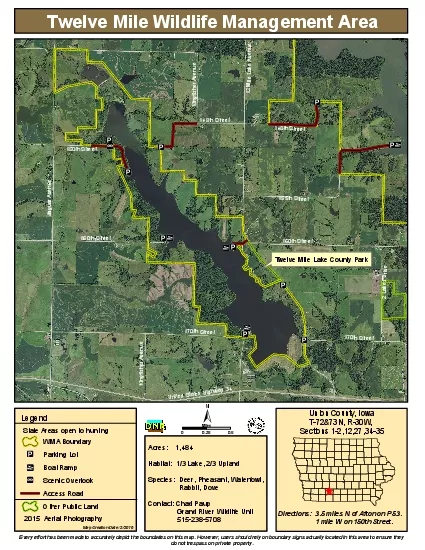
Twelve Mile Wildlife Management Area
by brianna
Acres 1484Habitat 1/3 Lake 2/3 UplandSpecies ...
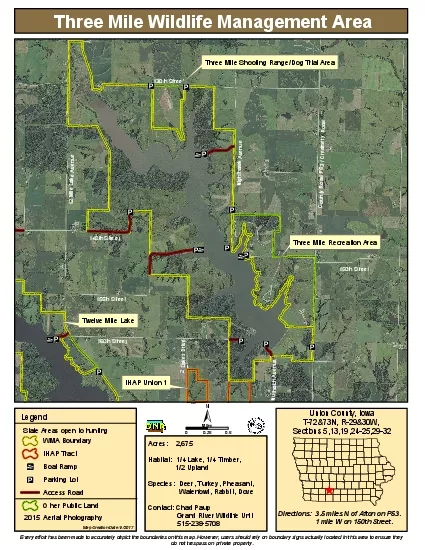
Three Mile Wildlife Management Area
by piper
Acres 2675Habitat 1/4 Lake 1/4 Timber ...
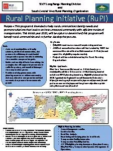
Rural Planning Initiative (RuPI)Purpose :This program is intended to h
by gelbero
Eligible Planning ActivitiesAccess Management stud...
DEPARTMENT OF COMMUN
by deena
ITY PLANNING, HOUSIN G AND DEVELOPMENT Planning D...
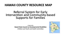
HAWAII COUNTY RESOURCE MAP
by rayfantasy
Referral System for Early Intervention and Communi...
Public Hearings August 2, 2016
by clustik
Board of County Commissioners. Case: . CDR-16-03-...
Briefing Outline History of Master Plan of Highways & Transitways
by startse
Purpose of MPOHT. Technical Elements of MPOHT Upda...
Bike Friendly RGV:
by myesha-ticknor
Bike Friendly RGV: Encouraging Bike Friendly Bu...
RD LINE EHS COUNTY ROAD TH SIDEROAD ND LINE EHS ND LI
by yoshiko-marsland
Possession of this map does not imply right of ac...
Privacy & Records Better Together
by karlyn-bohler
…………………………………………�...
Monterey County 2010 General Plan Consistency
by yoshiko-marsland
FORA Board of Directors. October 11, 2013. Backgr...
North Carolina Chief 101
by trish-goza
Fire Department . Ratings and Inspections. Chief ...
Jennifer Lana, GISP GIS Manager
by kittie-lecroy
Cobb County, GA. October 3, 2012. Cobb County use...
Overview of FEMA’s Risk MAP Program &
by giovanna-bartolotta
Taming the Terrain Beast. Arc Hydro River Worksho...
Public Hearings July 12, 2016
by briana-ranney
Board of County Commissioners. Case: . CDR-15-10...
Public Hearings January 26, 2016
by liane-varnes
Board of County Commissioners. Case: . CDR-15-06...
Public Hearings August 2, 2016
by marina-yarberry
Board of County Commissioners. Case: . PSP-15-12...
Creating Geographic Rating Area Maps:
by luanne-stotts
How to Combine Counties, . Split . Counties, . &a...
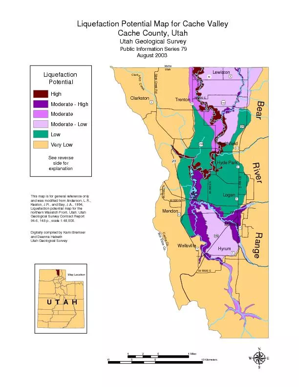
Liquefaction Potential Map for Cache ValleyCache County, UtahUtah Geol
by sherrill-nordquist
89 91 142 N 1600 EN 7200 WStink Creek RdN 3200 W 2...
Creating Geographic Rating Area Maps:
by natalia-silvester
How to Combine Counties, . Split . Counties, . &a...
Load More...