Explore
Featured
Recent
Articles
Topics
Login
Upload
Featured
Recent
Articles
Topics
Login
Upload
Search Results for ''
published presentations and documents on DocSlides.
e 161 De 1 4 and T5 e De is the spectral variation of emissi
by alyssa
(2) where q is the satellite observation angle an...
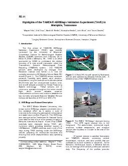
*Cooperative Institute for Meteorological Satellite Studies (CIMSS), U
by startlecisco
eteorological Data Reporting (TAMDAR) system. The...
by shoulderheinz
Sean Bailey. NASA Goddard Space Flight Center. UMa...
1 Assimilation of Satellite Snow Products
by collectmcdonalds
into . NCEP . Operational CFS/GFS System. Michael ...
Satellite Summer Workshop
by matterguy
1. Microwave Remote Sensing. With a Focus on Passi...
MAX-DOAS observations and their application to validations of satellite and model data in Wuxi, Chi
by sportyinds
. 1. ) . Satellite group, Max Planck institute for...
Joint Polar Satellite System (JPSS) Cross-Track Infrared Microwave Sounding Suite (CrIMSS) Environmental Data Record Validation Status
by ellena-manuel
Joint Polar Satellite System (JPSS) Cross-Track I...
Activities of the RA V WG-INFR
by phoebe-click
Ms Agnes Lane. Bureau of Meteorology. RA V Map. W...
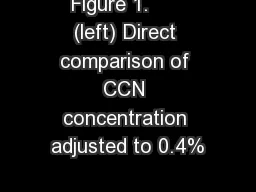
Figure 1. (left) Direct comparison of CCN concentration adjusted to 0.4%
by alida-meadow
supersaturation. and 499 nm AOD, both observed f...
Research To Operations (R2O, R2X and O2R)
by min-jolicoeur
Sid-Ahmed Boukabara. The JCSDA Summer Colloquium,...
WELCOME Mobile Applications Testing
by marina-yarberry
1. Copyright NataliaS@portnov.com. Mobile Applica...
Potential Soil Moisture Retrieval from Aquarius Instrument
by calandra-battersby
Mississippi State University. Geosystems. Resear...
An Optimization Method to
by aaron
Merge . Precipitation Products for . Land . Surfa...
Effect of Topography in Satellite Rainfall Estimation Errors: Observational Evidence across Contras
by olivia-moreira
Gebrehiwot. . Niguse. Tesfay. 1. , . Menberu. ...
Introduction to GAGAN &
by myesha-ticknor
GAGAN Enabled Receiver. By. Vineet Gera. Airports...
Dual Mode Connectivity for M2M
by tatiana-dople
Bill . Molesworth. Vice President, Terrestrial Wi...
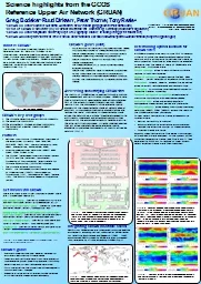
Science highlights from the GCOS
by conchita-marotz
Reference Upper Air Network (GRUAN) . Greg Bodek...
Diagnosing Climate Change from Satellite Sounding Measurements – From Filter Radiometers to Spe
by conchita-marotz
William . L. Smith . Sr. 1,2. .. ,. . Elisabeth ...
May 3, 2016 NOAA Satellite and Information Service |
by calandra-battersby
Office of Satellite and Product Operations. NESDI...
Overview of GPS Overview of how time is obtained from GPS
by tatyana-admore
One-Way time transfer. - Uncertainty analysis of ...
NOTICE: The information contained within this document is copyright
by sherrill-nordquist
© U.S. Coast Guard . Auxiliary Association. No a...
OSSE System Predictability in Preparation for 4DEnVar OSSEs
by tatiana-dople
Sean PF Casey. 1,2. , Ross N. Hoffman. 1,2. , Ro...
Patricia Pauley and Nancy
by giovanna-bartolotta
Baker. Naval . Research Laboratory. Monterey. , C...
Obtaining the User’s Position
by cheryl-pisano
Dr. Miguel A. Labrador. Department of Computer Sc...
Chapter 8: Networking and Internet Basics
by giovanna-bartolotta
1. 2. Satellites can be used for broadband commun...
May 3, 2016 NOAA Satellite and Information Service |
by pasty-toler
Office of Satellite and Product Operations. NESDI...
Maintaining Mission-Critical Operations
by olivia-moreira
and . Ensuring Connectivity . During a Disaster. ...
Navigation Systems and Their Implementation
by stefany-barnette
Michael Bekkala. Michael Blair. Michael Carpenter...
Project IAI-CRN3035 Towards usable climate science - information for decision-making and the provis
by stefany-barnette
PI: Cecilia Hidalgo (UBA) . . proyectoiai.serv.c...
Essential Questions What are some of the different types of remote sensing?
by pasty-toler
How are satellites and sonar used to map Earth’...
Collaboration Opportunities for the Application of Earth Observations from Space in Water Activitie
by tatyana-admore
Ms. Mary Kicza. Assistant Administrator. NOAA Sat...
Flight Path: Exploring a Career in Aerospace
by stefany-barnette
Engineering . Sheldon Clark. Raytheon. Agenda. To...
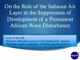
On the Role of the Saharan Air Layer in the Suppression of
by debby-jeon
Scott A. Braun. NASA/GSFC. Goals of this talk:. �...
Geodesy
by stefany-barnette
A look at the Earth. What is Geodesy?. - The Merr...
z Sponsored by:
by alida-meadow
The charge controller regulates the power from th...
2011 NOAA Satellite Direct Readout Conference
by luanne-stotts
Miami, Florida. April 4, 2011. Monitoring and Man...
Satellite 2015
by phoebe-click
Comparison Analysis of Global Horizontal Irradian...
LAP Profiles for GOES-R produced with the GOES
by trish-goza
SOunder. 1. Jun Li, . Zhenglong. Li, Yong-. Keu...
Satellite data constraints on the seasonal methane budget.
by stefany-barnette
Anthony Bloom. 1*. , . Kevin Bowman. 1. , . Meemo...
COMPARING THREE CANOPY REFLECTANCE MODELS WITH HYPERSPECTRAL MULTIANGULAR SATELLITE DATA M
by cheryl-pisano
Schlerf a W Verhoef a b H Buddenbaum c J Hill ...
Load More...