Explore
Featured
Recent
Articles
Topics
Login
Upload
Featured
Recent
Articles
Topics
Login
Upload
Search Results for 'remote sensing'
remote sensing published presentations and documents on DocSlides.
THE IDENTIFICATION AND ANALYSIS OF HUMAN CAUSATION IN ATROCIOUS AND ABNORMAL NATURAL DISASTERS BY THE METHOD OF SATELLITE REMOTE SENSING Na Yang Liangming Liu School of Remote Sensing and Informatio
by yoshiko-marsland
comcn or lmliu69sohucom Commission VIII WG VIII3 K...
Geogg124
by lindy-dunigan
TERRESTRIAL . CARBON: MODELLING and MONITORING. P...
UAV-Based Close Range Remote Sensing as a Monitoring Tool
by calandra-battersby
Christian . Knoth. , . Birte. Klein, . Till . Kl...
History of Remote Sensing
by marina-yarberry
Thanks to Jim Campbell for many of these slides!....
Remote sensing of aerosol-cloud interaction
by conchita-marotz
Presented by Lorraine A. Remer. NASA/Goddard Spac...
LONDON
by lindy-dunigan
’. S GLOBAL UNIVERSITY. MSc . Environmental Map...
Brief review of some remote sensing literature relevant to
by ellena-manuel
replace with your title. Your Name . ENVS4...
TAILING MODELLED AND MEASURED SPECTRUM FOR MINE TAILING MAP
by ellena-manuel
TUNISIAN SEMI-ARID CONTEXT. N. Mezned. 1,2. , S. ...
Remote Sensing and Soil Thermal Properties:
by liane-varnes
Eric Russell. 4/9/2010. Agron. 577: Soil Physics...
Satellite Remote SensingSatellite Remote SensingGE 4150GE 4150--Natura
by karlyn-bohler
Remote SensingRemote Sensing
Satellite Summer Workshop
by matterguy
1. Microwave Remote Sensing. With a Focus on Passi...
1 Remote sensing of snow in visible and near-infrared wavel
by marina-yarberry
Jeff Dozier – UCSB. NASA Snow Remote Sensing Wo...
Stefan-Boltzmann law governs the radiation of energy by a black body: M = {emissivity} * T
by eve
4. . Emissivity is a constant, so the energy radia...
International Archives of Photogrammetry Remote Sensing and Spati
by riley
al Information Sciences , Vol. XXXVIII, Part 5 Com...
Benthic Mapping using Remote Sensing Data
by bikershobbit
J. Cho. Department of Integrated Environmental Sci...
Hyperspectral Remote Sensing of Tropical Coastal Environments: the use of
by nersonvisa
. HICO data to derive water quality parameters in...
1 Satellite Remote Sensing I
by mrsimon
UV/vis observations of the troposphere. Lecture at...
Accuracies, Errors, and Uncertainties of Global Cropland Products
by cheryl-pisano
Accuracies, Errors, and Uncertainties of Global C...
Small Satellite Regulatory Issues: Data Security
by ellena-manuel
MARSH. . RICHMOND CLIENT ADVISORY COUNCIL MEETIN...
Module - V Integration of
by liane-varnes
GIS and Remote Sensing. Analysis and Presentatio...
Remote sensing data for detection of
by faustina-dinatale
Rhizoctonia solani . in sugar beets. Tavvs M. Alv...
Global Croplands Project
by myesha-ticknor
Remote Sensing of Global Croplands and their Wate...
Geographical Information Science/Remote Sensing/
by luanne-stotts
Modelling. Research interests . Chris Brunsdon,...
Future Capabilities in Remote
by marina-yarberry
Sensing and Air Quality Applications. Richard Kle...
Working Group: Data Products and Access
by lewis808
Robert Cook, . Oak Ridge National Laboratory. Terr...
UV-Vis remote sensing instruments - Retrieval and satellite
by cora
validation. M. Van . Roozendael. (BIRA-IASB). Con...
Welcome to the: 37th Tactical Fire Remote Sensing
by bitsy
Advisory Committee (TFRSAC) Meeting. 2. 9-30 Novem...
Simulation of Absorbing Aerosol Index & Understanding the Relation of NO
by amber
2. Column Retrievals with Ground-based Monitors. ...
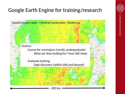
Google Earth Engine for training/research
by maisie
~300 km. Ground-based radar + Sentinel backscatter...
How well are we able to close the water budget at the global scale?
by thomas
Fanny Lehmann. , Bramha Dutt Vishwakarma, and Jona...
Vegetation Supergroup breakout report
by ivy
(Dynamics & Distribution, Structure, Hyperspec...
Overview of the Soil Merge (SMERGE) root-zone soil moisture product
by brianna
Sponsored by the NASA Climate Indicators and Data ...
Jeff Czapla-Myers Remote Sensing Group, College of Optical Sciences
by mila-milly
University of . Arizona. NASA MEASURES #. NNX08AT0...
GIS Training Introduction to Remote Sensing
by ariel
Satellite imagery. Low resolution satellite imager...
1 Radiometry – remote sensing via microwave emission
by evelyn
Chris Allen (callen@eecs.ku.edu). Course website U...
Erika Podest, Jet Propulsion Laboratory, California Institute of Technology
by evelyn
The Applied Remote Sensing Training (ARSET) Progra...
Introduction to Google Earth Engine (GEE) and Remote Sensing and Climate Applications
by belinda
Zivan . Yoash. Inter University Computation Center...
6 th Year of continued effort towards the goal of GRSS
by bery
ACTIVITIES. :. Expert Talks: 5. 2. National Worksh...
Topographic LIDAR: A Revolutionary Remote Sensing Technology
by Hdmsarch
A topographic LIDAR (Light Detection and Ranging) ...
The detection of irrigation through remote sensing soil moisture and a land surface model: a case
by PeacefulPassion
Jacopo . Dari. . (1). , Pere Quintana-. Seguí. ...
Load More...