Explore
Featured
Recent
Articles
Topics
Login
Upload
Featured
Recent
Articles
Topics
Login
Upload
Search Results for 'Lidar-Fwf'
Lidar-Fwf published presentations and documents on DocSlides.
Catherine Myers, PE University of Portland
by yoshiko-marsland
Shiley School of Engineering. Portland Oregon. Fo...
Determining Crossing Conductor Clearance Using Line-Mounted LiDAR
by stefany-barnette
McCall, J., Spillane, P., Lindsey, K.. Lindsey Ma...
Turbulence and Heterogeneous Wind
by giovanna-bartolotta
Conditions in the Field of Wind . Energy. MSc . T...
Soluții profesionale de productivitate ridicată pentru dezvoltarea operațiunilor aeroportuare di
by faustina-dinatale
Gabriel MILITARU, Director . A 25-a . Conferinț....
__________ Introduction Importance
by yoshiko-marsland
Wildlife Habitat. Nutrient Cycling . Long-Term Ca...
Accuracy of dual-Doppler
by cheryl-pisano
lidar . retrievals . of . near-shore winds. Nikol...
CE 365K Hydraulic Engineering Design
by debby-jeon
Concepts using in Exam 1. 6 March 2014. Professio...
Geospatial Analytics and
by mitsue-stanley
M. odeling Laboratory. Helena Mitasova . http://s...
Determination of an Optimum Sector Size for Plan Position
by natalia-silvester
Indicator Measurements using a Long Range Coheren...
Mapping Technology
by karlyn-bohler
Overview. Philip Gershkovich. President. Cooper A...
EE698G: Probabilistic Mobile Robotics
by liane-varnes
LIDAR ODOMETRY AND MAPPING (LOAM). memBERS. :. Aa...
AWARE
by ellena-manuel
Assessment of Wood Attributes using Remote . Sens...
T ropospheric
by conchita-marotz
O. zone . L. idar . Net. work (. TOLNet. )- . Lon...
The Robot Revolution
by alexa-scheidler
has been Postponed. (until we can debug the senso...
Properties of a
by trish-goza
kNN. tree-list imputation strategy for predictio...
Predicting an Invasive Species’ Distribution with
by celsa-spraggs
LiDAR-derived Topography. Citation: . Hannam, M.,...
Tiffany L. Caudle, Thomas A. Tremblay, Jeffrey G. Paine, Jo
by marina-yarberry
Bureau of Economic Geology. Jackson School of Geo...
Citation:
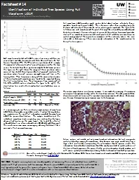
by debby-jeon
Vaughn, N. and L.M. . Moskal. , 2011. Identificat...
METR
by calandra-battersby
5970.002. Advanced . Atmospheric Radiation. Dave ...
Comparison of
by test
lidar. water vapor measurements at Fixed PISA 2....
Application of a High-Pulse-Rate, Low-Pulse-Energy Doppler
by trish-goza
Transport Measurement. Mike Hardesty. 1,4. , . Sa...
An Introduction to Radar and Lidar Remote Sensing
by conchita-marotz
Credit to: Weile Wang. Gustav Klimt (1862-1918), ...
Kavaya
by myesha-ticknor
1. Flight Results of the Langley DAWN Coherent Wi...
CE 365K Hydraulic Engineering Design
by sherrill-nordquist
Inlet Design. By David R. Maidment. Spring 2016. ...
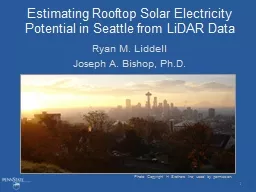
Estimating Rooftop Solar Electricity Potential in Seattle f
by kittie-lecroy
Ryan M. Liddell. Joseph A. Bishop, Ph.D.. Photo C...
Kentucky Aerial Photography and Elevation Data Program - KY
by myesha-ticknor
National Height Mod Partner Meeting. M. ay 1, 201...
Nihanth W.
by pamella-moone
Cherukuru. a. Ronald . Calhoun. a. Manuela . Lehn...
Measurements of Flow Distortion within the CSAT3
by lindy-dunigan
Sonic Anemometer. T.W. Horst. . and S.R. . Semme...
Global rangelands and their role in food security
by yoshiko-marsland
Temuulen “. Teki. ” Sankey. Northern Arizona ...
Hydro Treatments of
by alida-meadow
Lidar-Derived DEMs. Stereo DTM. (Topographic Surf...
Jeff Stith,
by trish-goza
Andrew . Gettelman. NCAR is sponsored by the Nat...
Hydrologic Measurement
by myesha-ticknor
Precipitation. Evaporation. Streamflow. Channel ....
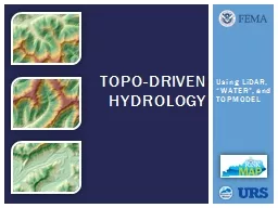
Using
by liane-varnes
LiDAR. , “WATER”, and TOPMODEL. TOPO-Driven H...
LiDAR Landslide
by myesha-ticknor
Mitigation. . Bob Hickey. Although gravity actin...
Upendra N Singh
by luanne-stotts
1. , Jirong Yu. 1. , Yingxin Bai. 2. , Mulugeta P...
AGIC 2015
by lindy-dunigan
Education & Training Symposium. September . 2...
Space-based Wind
by yoshiko-marsland
Lidar. Working Group. Bar Harbor, Maine. August ...
__________
by alexa-scheidler
Introduction. Importance . Wildlife Habitat. Nutr...
Monitoring Forest Management Activities using Airborne
by briana-ranney
LiDAR. and ALOS PALSAR. Akira Kato. 1. , Manabu ...
Processing Terrain Data in the River Proximity
by pasty-toler
Arc Hydro River Workshop. December 1, 2010. Erin ...
Load More...