Explore
Featured
Recent
Articles
Topics
Login
Upload
Featured
Recent
Articles
Topics
Login
Upload
Search Results for ''
published presentations and documents on DocSlides.
Best Practices for Mapping your Master Data Landscape
by cheryl-pisano
Rob Loranger – Product Manager | ER/Studio. Age...
E1: Carnivore Community Mapping
by ellena-manuel
This activity will help you to learn about the la...
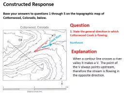
Question Explanation
by mitsue-stanley
When a contour line crosses a river valley it mak...
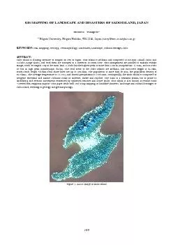
GIS MAPPING OF LANDSCAPE AND DISASTERS OF SADO ISLAND JAPAN Hiromits
by unita
Figure 1. ALOS Image of Sado Island 1429 The Inte...
Risk Road Map: Navigating the Evolving Risk Landscape in the Hedge Fund World
by messide
Moderator: Brian . Ruane. , BNY Mellon. Panelists:...
Crushing Soda Cans: Predicting the Stability Landscape of Shell Buckling
by cheryl-pisano
Harvard MRSEC. DMR-1420570 . Crushing a soda can ...
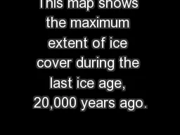
This map shows the maximum extent of ice cover during the last ice age, 20,000 years ago.
by karlyn-bohler
What would you say was the extend of the ice cove...
Capability Brown Festival 2016
by faustina-dinatale
The Festival team. Ceryl Evans – Director. Mel ...
Sentinel Landscape Workshop
by giovanna-bartolotta
March, 2014. An issue bounded Sentinel Landscape....
Load More...