Explore
Featured
Recent
Articles
Topics
Login
Upload
Featured
Recent
Articles
Topics
Login
Upload
Search Results for 'gis data'
gis data published presentations and documents on DocSlides.
Week 4
by phoebe-click
JPL Snow Server. Chris . Mattmann. , Thomas H. Pa...
Shuming Bao
by luanne-stotts
China Data Center. University of Michigan. Spatia...
Cartography I
by lindy-dunigan
LECTURE 1. Cartography I. History of Cartography....
Jim Irvine
by trish-goza
Head of Digital Resources and the Collins Newsroo...
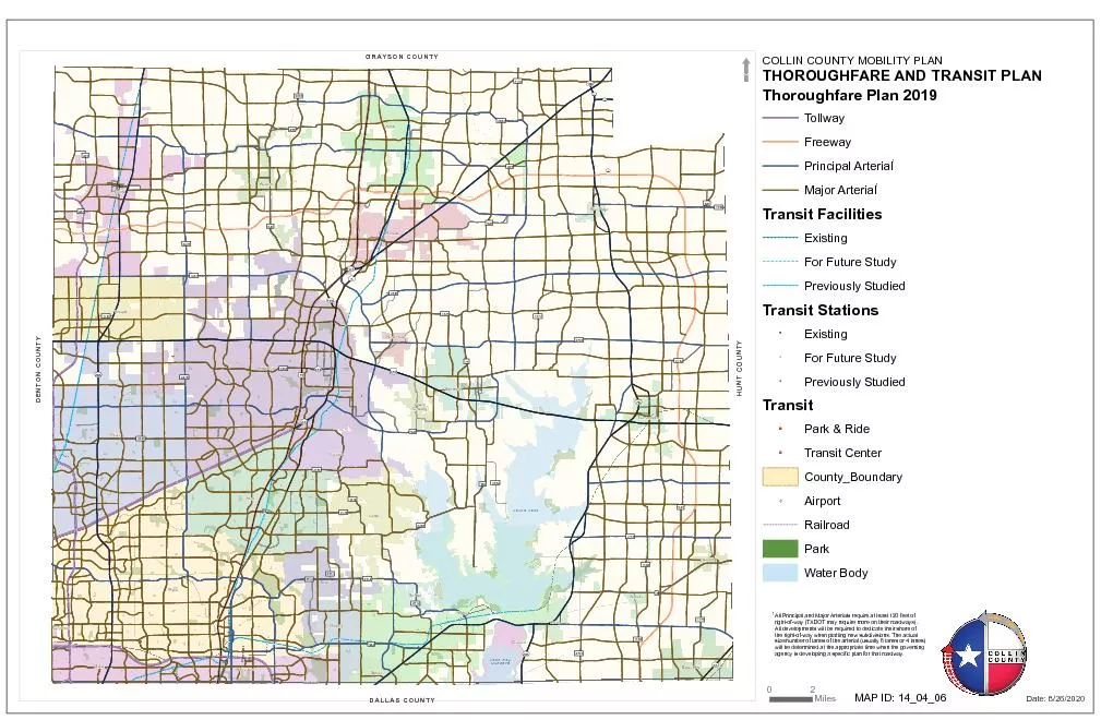
Information TechnologySource data compiled from Collin County GIS data
by min-jolicoeur
01234 AeroCountryAirportMcKinneyNationalAirport DA...
Seeing
by lois-ondreau
Is . Believing. visualizing. . geospatial. dat...
Facetted browsing of Rockcarvings
by lindy-dunigan
Fredrik Palm, HUMlab . 2012. How does ”Hacka”...
RTI Project Overview
by test
Frank Betz. Chief Operating Officer. Rahall Trans...
Regional GIS Users Group Meeting
by olivia-moreira
Wednesday, February 18. th. 2009. 10:00 AM - Noo...
Geographic tools and resources
by liane-varnes
MEASURE . Evaluation. Lesson Objectives. Showcase...
SCADM/SCAGI joint meeting, 31 July 2010, Buenos Aires
by myesha-ticknor
SCAGI . progress since 2009 Amsterdam meeting. Ad...
Layouts:
by lindy-dunigan
Creating maps and. . figures using . ArcMap. 1. ...
Mrs. Keith-
by phoebe-click
Houle. 11:00 E. 10:00 C. Red. RB. Bank. High. Sch...
GIScience: The Next 10 Years
by yoshiko-marsland
Michael F. Goodchild. University of California. S...
Precision Geocoding through Quality Addresses
by marina-yarberry
Address Quality for Location Intelligence. Flight...
Parks, Trails, &
by natalia-silvester
Rec. Facilities. NRPA Data Model. The National R...
APDM 6.0
by debby-jeon
ArcGIS Pipeline Data Model. Peter Veenstra. APDM ...
RNR 419/519
by yoshiko-marsland
Introduction to . Cartographic Modeling . Analysi...
Agricultural Feasibility Analysis in China: A GIS-based Spa
by trish-goza
Presenter: Fei . Carnes. Date: July 17, 2013. Ema...
1 REVIEW
by olivia-moreira
OF . RAPDRP PART A PROGRESS. IN KARNATAKA. Aug 2...
Understanding Servers
by liane-varnes
Keith T. Weber. GIS Training and Research Center....
Coordinate Systems,
by briana-ranney
Datums. and Map . Projections. D’Arcangelis. 1...
Marine Geospatial
by celsa-spraggs
Ecology Tools. Jason Roberts, Ben Best, Dan Dunn,...
Applied Cartography and Introduction to GIS
by calandra-battersby
GEOG 2017 EL. Lecture-4. Chapters 7 and 8. Locati...
Shuming Bao
by pasty-toler
China Data Center. University of Michigan. Spatia...
Applied Cartography and Introduction to GIS
by tatiana-dople
GEOG 2017 EL. Lecture-5. Chapters 9 and 10. Commo...
FORCIP+ FOREST ROADS FOR CIVIL PROTECTION GA No. ECHO/SUB/2015/718661/PREP20
by zain242
PROTECTION. GA No. ECHO/SUB/2015/718661/PREP20. Pr...
Maps and GIS Historical Maps
by melanie
The oldest map?. Konya . town map, Turkey, c. 6200...
By- jay patel (130110105027)
by dandy
aakash. . patel. (130110105001). urvish. . soni...
GIS Map data Living Bog
by walsh
Landownership details for each . site. Baseline Ha...
Hydro Networks in GIS Network model
by bery
Flow on Networks. Hydrologic networks. Linear refe...
GIS Training Bathymetry, geomorphology, habitat
by bency
Bathymetric charts. Bathymetric charts are produce...
VEGA-GEOGLAM Web-based GIS for crop monitoring
by caroline
and decision support . in agriculture. Evgeniya . ...
[BOOK]-Placing History: How Maps, Spatial Data, and GIS Are Changing Historical Scholarship
by AprilBennett
In the last decade, historical GIS has emerged as ...
[EBOOK]-Placing History: How Maps, Spatial Data, and GIS Are Changing Historical Scholarship
by GloriaAnderson
In the last decade, historical GIS has emerged as ...
HARVEY J MILLER
by angelina
1 Department of GeographyThe Ohio State Universit...
Partnership Opportunities and the Evolving Michigan
by elena
Statewide Authoritative Imagery and LiDAR Program ...
Inscribing Environmental Memory in the Icelandic Sagas (IEM)
by sequest
Steven Hartman. steven.hartman. @. miun.se. . The...
A GIS Analysis of the Mexican Drug War
by karlyn-bohler
A GIS Analysis of the Mexican Drug War Will Gilra...
TOTAL DATA CAPTURE intuitive
by olivia-moreira
- . fast. . - . reliable. EJEMPLOS DE CAPTURA D...
Load More...


![[BOOK]-Placing History: How Maps, Spatial Data, and GIS Are Changing Historical Scholarship](https://thumbs.docslides.com/957368/book-placing-history-how-maps-spatial-data-and-gis-are-changing-historical-scholarship.jpg)
![[EBOOK]-Placing History: How Maps, Spatial Data, and GIS Are Changing Historical Scholarship](https://thumbs.docslides.com/954246/ebook-placing-history-how-maps-spatial-data-and-gis-are-changing-historical-scholarship.jpg)