Explore
Featured
Recent
Articles
Topics
Login
Upload
Featured
Recent
Articles
Topics
Login
Upload
Search Results for 'gis data'
gis data published presentations and documents on DocSlides.
LECTURING ON SATELLITE IMAGERY PROCESSING AND GIS BASED ON
by lois-ondreau
Fatwa . Ramdani. *. . *. Geo-environment, Instit...
Making NASA Data Sets Available
by stella
with . GIS-based Web-Applications . for Energy: PO...
Unit 2 Data Processing & Management
by nicole
TYIT SEM VI. D. ata processing system. Refers . to...
Free and Open Source Geospatial Software and Data
by tawny-fly
Ioannis. . Kokkinidis. Geospatial and Environmen...
Spatial Data Management -The
by briana-ranney
St.Vincent. and the Grenadines Chapter. Author: ...
Introduction to ArcGIS Planetary Data Analysis
by min-jolicoeur
Peter Fawdon. Department of Earth and Planetary S...
9. GIS Data Collection
by tawny-fly
Overview. Introduction. Primary data capture. Sec...
Free and Open Source Geospatial Software and Data
by tawny-fly
Ioannis. . Kokkinidis. Geospatial and Environmen...
Geographic Data Primitives
by myesha-ticknor
Large number:. Points, multiipoints, lines, polyl...
Data Sources and Conversion Feeding the GIS Dr.
by lindy-dunigan
Data Sources and Conversion Feeding the GIS Dr. Ah...
Understanding Networks
by marcellus
Keith T. Weber, GISP. GIS Director. ISU-GIS Traini...
PSAP Launch March 11, 2015 Crisis City, Kansas
by colson
Crisis City, Kansas. Statewide NG9-1-1. 1000 Welco...
Esri’s ArcGIS Enterprise
by luna
IT4GIS. Keith T. Weber, GISP. GIS Director. ISU-GI...
Session 10 – Use of geospatial tools during census enumeration
by jade
By. Abdel . Gadir. Mohamed Ahmed . elsadig. CBS ...
NENA Information Document for Synchronizing Geographic Information Sys
by elina
NENA Information Document for Synchronizing Geogra...
GIS Data in PDS4 Trent Hare and Lisa Gaddis
by projoutr
(and Cartography and Imaging Node). GOALS. Problem...
Topic 2. GIS Resources and Projects in DILA
by basidell
Outline. Project1. : Visualizing . and Querying Ch...
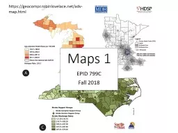
EPID 799C Fall 2018 Maps 1
by min-jolicoeur
https://geocompr.robinlovelace.net/adv-map.html. ...
Geospatial Research Methods
by natalia-silvester
Instructor: Jim Graham. E-mail: James.Graham@Humb...
Geographic Information
by pasty-toler
Systems. ASM 215. Feb 2013. Larry Theller. Schedu...
GIS APPLICATION IN FIREWALL LOG VISUALIZATION
by tawny-fly
Penn State MGIS 596A Peer Review. Presenter: Juli...
Module - V Integration of
by liane-varnes
GIS and Remote Sensing. Analysis and Presentatio...
Understanding Vector and Raster
by liane-varnes
DataTitle. Larry C. . Shubat. Professor. The Univ...
Advancing Your Skillset
by karlyn-bohler
To Get The Job Done. Scott Snider, GISP. GIS Coor...
www.vita.virginia.gov Next Generation 9-1-1
by debby-jeon
Decision Maker Webinar. October 7, 2015. 1. Exist...
The Nuts & Bolts of EGIS:
by giovanna-bartolotta
HELP SAVE PINKY!!!!!!. Presented by . John R. Woo...
Yueming Wu , Ph.D., GISP
by aaron
GIS Manager. May 9, 2012. WVDOT GIS Strategic &a...
September 23, 2015 Statewide Geospatial Advisory Council
by briana-ranney
Call to order and . introductions. Approval . of ...
IMPLEMENTING GOVERNMENT-WIDE ENTERPRISE
by ellena-manuel
GIS;. THE FEDERATED MODEL. James E. Mitchell, Ph....
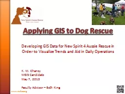
Applying GIS to Dog Rescue
by celsa-spraggs
Developing GIS Data for New Spirit 4 Aussie Rescu...
GIS Mapping of Indiana’s
by pamella-moone
Lake . Michigan Shoreline. Kaitlyn McClain. Coast...
Welcome to
by ellena-manuel
Urban Geographic . Information systems. !. Dr. Ry...
Crime Mapping Level 2
by min-jolicoeur
BCJI . Webinar. February 24, 2015. Offense/Arrest...
Kurt Menke, GISP, Bird
by natalia-silvester
’. s Eye View. John Scott, Center for Public Se...
Using GIS with Real-time Water Quality Assessment to Guide
by faustina-dinatale
Matthew Schwartz. University of West Florida. All...
Maintaining Pipeline Integrity with
by lindy-dunigan
GIS . & Smart Pig Data . Analysis. Taryn . Mo...
Underexplored Research Topics
by olivia-moreira
An Industry Perspective. Erik Hoel. esri. e. sri....
A New World for Mapping
by test
John . Spencer. Spatial Analysis Unit. October 5,...
How to make flash cards out of PowerPoint slides!
by tatyana-admore
See slide 8 for details. 1. Which one of these ca...
Lecture 2:
by kittie-lecroy
Part 1. Understanding Spatial Data Structures. Pa...
Load More...