Explore
Featured
Recent
Articles
Topics
Login
Upload
Featured
Recent
Articles
Topics
Login
Upload
Search Results for ''
published presentations and documents on DocSlides.
UAV/S in GIS Brookhaven College
by min-jolicoeur
Our 1. st. Flight Operation. July 2016. Can we f...
GIS @ the New U Nancy
by luanne-stotts
Hoalst. Pullen, PhD. Mark W. Patterson, PhD. Fir...
GIS Capabilities of State-Wide
by tatyana-admore
Mutual Aid Assets. James Cueno, City of Galesburg...
Streamlining GIS Data & Solution Management
by phoebe-click
Stephen Hale. GIMS DB Administrator. ODOT. Ohio G...
Lesson 3 GIS Fundamentals
by lois-ondreau
MEASURE Evaluation. PHFI Training of Trainers. Ma...
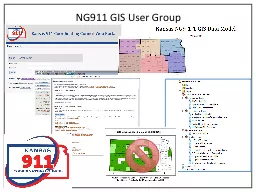
NG911 GIS User Group Led
by trish-goza
by GIS Committee. Quarterly (or as needed) confer...
NYS GIS Association Annual Meeting
by phoebe-click
Tuesday, October 21, 2014. 4:00 – 5:30 PM. Skan...
Part I: GIS Tools for Water Planners
by lois-ondreau
and. Part II: Sierra Nevada Conservancy . GIS Wat...
The Future of GIS:
by cheryl-pisano
a few thoughts. Ron Briggs Ph.D. GISP. Professor ...
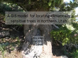
A GIS model for locating climatically sensitive trees
by faustina-dinatale
in northern Utah. Eric Allen. Fall 2011. GIS 6440...
GIS at a Regional Level
by celsa-spraggs
Regional Planning & Development Councils and...
Winter 2011 GIS Institute
by tawny-fly
Space:. Questions & Tools. First Off: Introdu...
Qatar’s Nation-Wide GIS
by natalia-silvester
Cooperation on Local and Regional Levels. Dr. Moh...
GIS as Applied to Disaster Management in Outlying and Non-M
by alida-meadow
James Cueno, City of Galesburg. jcueno@ci.galesbu...
A GIS-based comparison of pre- and post-lignite strip mine
by marina-yarberry
A Progress Report by. L. Joy Mercier. on Tuesday,...
Integrated Suite of GIS Applications for the Geosciences Encom TM Discover TM Encom TM Discover TM Suite Uncover what lies beneath your data with GIS solutions purpose built for the geosciences from
by sherrill-nordquist
GIS for Geosciences The Encom Discover Suite is t...
GIS (Geographic Information Systems)
by ellena-manuel
Applications in marketing. Austin College. April ...
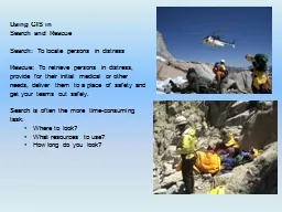
Using GIS in
by cheryl-pisano
Search and Rescue. Search: . To locate persons in...
Ten Years of Gulfport GIS
by kittie-lecroy
Survival and Evolution . since . Hurricane Katrin...
Chapter 10: Health and GIS
by kittie-lecroy
An Introduction to the Geography of Health. Data ...
LECTURING ON SATELLITE IMAGERY PROCESSING AND GIS BASED ON
by lois-ondreau
Fatwa . Ramdani. *. . *. Geo-environment, Instit...
A GIS-based comparison of pre- and post-lignite strip mine
by myesha-ticknor
A Progress Report by. L. Joy Mercier. on Tuesday,...
GIS Matthew Rosencrans
by test
Tom . DiLiberto. Outline . What is GIS?. What can...
INTEGRATING SURVEYING AND GIS
by yoshiko-marsland
PREPARED FOR:. WVAGP SEMINAR. Jared D. Wilson. In...
Applied GIS On Kuwait’s water
by natalia-silvester
Duaij AlRukaibi. GIS in Water R...
Data Sources and Conversion Feeding the GIS Dr.
by lindy-dunigan
Data Sources and Conversion Feeding the GIS Dr. Ah...
Understanding Networks
by marcellus
Keith T. Weber, GISP. GIS Director. ISU-GIS Traini...
PSAP Launch March 11, 2015 Crisis City, Kansas
by colson
Crisis City, Kansas. Statewide NG9-1-1. 1000 Welco...
Evaluation support study on Geographical Indications and Traditional
by ethlyn
Specialities. Guaranteed protected in the EU. Fin...
Esri’s ArcGIS Enterprise
by luna
IT4GIS. Keith T. Weber, GISP. GIS Director. ISU-GI...
Session 10 – Use of geospatial tools during census enumeration
by jade
By. Abdel . Gadir. Mohamed Ahmed . elsadig. CBS ...
Making NASA Data Sets Available
by stella
with . GIS-based Web-Applications . for Energy: PO...
Unit 2 Data Processing & Management
by nicole
TYIT SEM VI. D. ata processing system. Refers . to...
Geographic Information Systems - GIS
by ashley
Jessica Griffin. Intro to GIS. Geography is the sc...
Understanding GIS: An ArcGIS Pro Project Workbook (Understanding GIS, 4)
by majestykodi
It’s no secret that this world we live in can be...
Applied Geostatistics
by Dollface
http://www.acsu.buffalo.edu/~lbian/GEO497_597.html...
Overview of Geographical Indication (GI) and Country Name Protection in the Domain Name System (DNS
by jovita
WIPO Internet Domain Name Processes . (“WIPO 1вЂ...
EVALUACIÓN TÉCNICA INFORMÁTICA DEL SISTEMA DE INFORMACIÓN GEOGRÁFICA DE LA EEQ
by heavin
Octubre 2015. SIG. SIG en la EEQ:. MisiГіn. :. Pr...
An ISO 9001:2008 Registered
by freya
CMMI Maturity Level 3 Company. 1430 Spring Hill Rd...
The Nuts & Bolts of Enterprise Geographic Information Systems (EGIS):
by phoebe
A Success Story. The City of Oberlin’s EGIS Proj...
Load More...