Explore
Featured
Recent
Articles
Topics
Login
Upload
Featured
Recent
Articles
Topics
Login
Upload
Search Results for 'data vegetation'
data vegetation published presentations and documents on DocSlides.
Advantages of Monitoring Vegetation Restoration With
by gabriella
the Carolina Vegetation Survey . Protocol. M. Forb...
Mapping Understory Vegetation Using Phenological Characteristics Derived from Remotely Sensed Data
by martin
Mao-Ning Tuanmu. 1. , Andrés Viña. 1. , Scott B...
Use of Solar Induced Fluorescence and LIDAR to Assess Vegetation
by barbara
Change and VulnerabilityMarch 16 25 2021Part 2 Que...
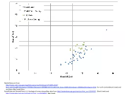
Rainfall data are from
by mitsue-stanley
http://. www.ncdc.noaa.gov/cag/time-series/us/33/...
Florida Key Deer Land Acquisition
by cheryl-pisano
Edward Jackson. 11/18/2014. RENR – 405 – 599....
Enhancing vegetation productivity forecasting using remotel
by olivia-moreira
Wade T. Crow. USDA Hydrology and Remote Sensing L...
Distinguishing vegetation communities
by stefany-barnette
Land . Cover Mapping and Habitat Analysis. Unders...
An expert system for generating restoration targets for Car
by mitsue-stanley
Elizabeth R. Matthews, . Michael . Lee, M. Forbes...
Geogg124
by lindy-dunigan
TERRESTRIAL . CARBON: MODELLING and MONITORING. P...
East African Rift
by marina-yarberry
Rwenzori. What’s Torres-Acosta et al. objective...
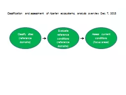
Development of analytical tools for classification and assessment
by kittie-lecroy
Development of analytical tools for classificat...
Abstract: Dryland river basins frequently support both irrigated agriculture and riparian vegetation and remote sensing methods are needed to monitor water use by both crops and natural vegetation in irrigation districts. We developed an algorithm for e
by tatyana-admore
Abstract: Dryland river basins frequently suppo...
Vegetation Criteria How useful is it?
by rivernescafe
Ken Sargent . Three Parameter System. Hydrology . ...
Vegetation Criteria How useful is it?
by stylerson
Ken Sargent . Three Parameter System. Hydrology . ...
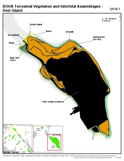
Northeastern
by melody
Old FieldBlack PineForestSea wallBeachRecreational...
NOAA’s Climate Data
by min-jolicoeur
Records. . (CDRs). Walter Glance . (CDR Program ...
Cheeseboro Canyon Team Alpha
by onionchevrolet
Michael Diaz, Fabricia Oliveira, Nick Reynoso, Ali...
NWS / SPoRT Coordination Call
by myesha-ticknor
August 19, 2010. Topics. : LIS, SST Composite, Te...
Models
by ellena-manuel
. in. . GIS. A. . mode. l. . i. s. . a. . d...
1 Vegetation Modeling
by danika-pritchard
Outline. 2. Model types. Predictive models. Predi...
F. Fussi
by alexa-scheidler
(1). , L. Fumagalli. (1). , T. Bonomi. (1). , F. ...
1 Quantitative Vegetation Analysis with Forest
by lois-ondreau
Inventory Vegetation. Outline. Objective . Review...
IFSAR and terrestrial LIDAR for vegetation study in Sonora,
by min-jolicoeur
Created for GIS in Water Resources 2013 by Kendal...
EVALUATION OF SMAP LEVEL 2 SOIL MOISTURE ALGORITHMS USING SMOS DATA
by mitsue-stanley
Rajat Bindlish. 1. , Thomas Jackson. 1. , Tianjie...
Mothematical Modeling:
by stingraycartier
Temporal and Spatial Models of Moth Distribution a...
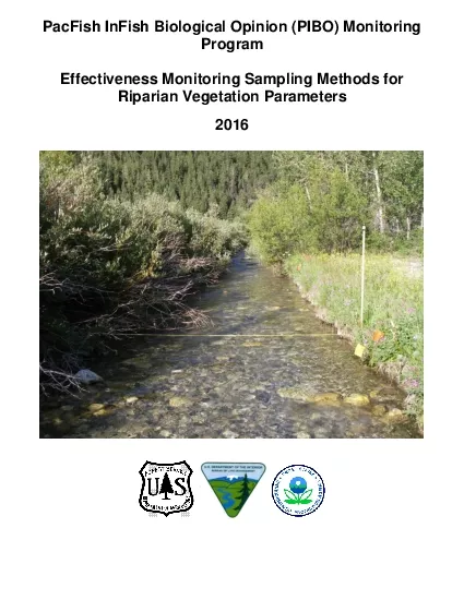
acFish InFish Biological Opinion PIBO Monitoring
by kylie
PProgramEffectiveness Monitoring Sampling Methods ...
Land account
by jacey
sand Ecosystem ExtentDRAFTAuthors Emil Ivanov and ...
Day 2: Data Collection Day
by hazel
Three-lesson education module developed by the Aso...
1 Vegetation Modeling Outline
by brianna
2. Model types. Predictive models. Predictor data....
Leveraging GIS to Enhance the Study of Rights-of-Way Ecology
by alexa-scheidler
Grant Wills - The Pennsylvania State University....
Update on 30-m approach to cropland extent
by kittie-lecroy
Cristina Milesi. September 2014. Global . Food Se...
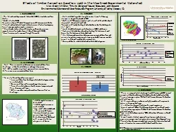
Effects of timber harvest on baseflow yield in the Mica Cre
by tatyana-admore
Wes Green, Will Drier, Tim Link (College of Natur...
Data Collection sheets
by calandra-battersby
Vegetation . diversity, coverage & height in....
Graham Earl & Tom Dargie: Part 1
by karlyn-bohler
Interpreting sand dune habitat change at Sandwich...
Remote Sensing of Ecosystem Productivity Using MODIS
by alexa-scheidler
. F. red Huemmrich, UMBC/GSFC . John Gamon, Univ...
Detecting Land Cover Land Use Change in Las Vegas
by aaron
Sarah Belcher & Grant Cooper. December 8, 201...
GEOGG142 GMES
by trish-goza
Global vegetation parameters from EO. Dr. Mat Dis...
Emergent Vegetation Mapping
by lois-ondreau
2010. Rice Lake NWR. Josh Knopik, WRS. Jessica Ca...
Reconstructing Paleoenvironments of Southwestern New Mexico Archaeological Sites
by olivia-moreira
1. LOPEZ. , . Adrianne, 1. . SUAREZ, Marina B. .,...
MS005 Air and soil temperature data from the Reference Stand network a
by obrien
Reference Stand Plant community RS07 Tshe/Pomu - O...
Load More...