Explore
Featured
Recent
Articles
Topics
Login
Upload
Featured
Recent
Articles
Topics
Login
Upload
Search Results for 'data gis'
data gis published presentations and documents on DocSlides.
BENEFICIAL OWNERSHIP AND THE USE OF GIS DATA
by alexa-scheidler
Ara. Lou Margaret Aguilar. Outline. What is bene...
Campus Populations
by faustina-dinatale
Modeling and Visualizing the Changing . Concentra...
Supporting an Accessible Geodetic Control Network for Cali
by kittie-lecroy
Presented by:. The California GIS Council's . Geo...
Utilization
by pamella-moone
. of GIS in Japan. Hiroyuki KITADA , Yumi SEKINE...
Role of Spatial Database
by myesha-ticknor
in. Biodiversity Conservation Planning. Sham . Da...
June 24, 2015
by mitsue-stanley
Statewide Geospatial Advisory Committee. Call to ...
An Introduction to GIS
by myesha-ticknor
Karen Hogenboom (with thanks to Leo Dion). Numeri...
GS6384 Vault is for More than Engineers: Integrating AutoCA
by luanne-stotts
Stephen Brockwell. President, Brockwell IT Consul...
Geographic Information Systems
by ellena-manuel
Department of Surveying and . Geomatics. By Shoko...
Crime Mapping Level 1
by alida-meadow
BCJI . Webinar. February 23, 2015. What is a GIS?...
Geographic Information Systems - GIS
by ashley
Jessica Griffin. Intro to GIS. Geography is the sc...
Applied Geostatistics
by Dollface
http://www.acsu.buffalo.edu/~lbian/GEO497_597.html...
An ISO 9001:2008 Registered
by freya
CMMI Maturity Level 3 Company. 1430 Spring Hill Rd...
The Nuts & Bolts of Enterprise Geographic Information Systems (EGIS):
by phoebe
A Success Story. The City of Oberlin’s EGIS Proj...
x0000x000070 xMCIxD 0 xMCIxD 0 xMCIxD 1 xMCIxD 1 xMCIxD 2 xM
by desha
7-1 GIS GEOGRAPHIC INFORMATION SYSTEMSWhat is GI...
GIS Site Structure / Address Points
by mrsimon
Richard Kelly & Cheryl Benjamin, Workgroup Co-...
The City of New Braunfels Parks and Recreation Asset Management Project
by calandra-battersby
The City of New Braunfels Parks and Recreation As...
Presented by: Craig Amey, PS
by pamella-moone
GEOG. 596:. Adviser: Dr. Frank Derby. A Python-B...
Community-wide urban stormwater planning utilizing LiDAR, the WinSLAMM model and GIS
by cheryl-pisano
Dan Murphy. Rebecca Gronewold. UNI GeoTREE Center...
Cartographic Modeling Language Approach for
by lois-ondreau
CyberGIS. : . A Demonstration with Flux Footprint...
GIS in Water Resources Fall 2011
by natalia-silvester
Groundwater Tools for GIS. Built-in Tools. Time-e...
How does a community utilize ESRI’s
by min-jolicoeur
ArcGIS Online functionality and incorporate. into...
Research Opportunities in Location Analytics, Spatial Decis
by lois-ondreau
Findings from . An AIS-based Survey. Namchul Shin...
Using GIS to Compare all M&R Strategies for Asphalt Roa
by test
CEE 6240: GIS in Water Resources. By: Antonio Fue...
Using GIS to Map
by ellena-manuel
Chromium Occurrence in Drinking Water. Nate Roge...
Geospatial
by faustina-dinatale
(GIS&RS) . Education/Training. Applied resear...
BENEFICIAL OWNERSHIP AND THE USE OF GIS DATA
by olivia-moreira
Ara. Lou Margaret Aguilar. Outline. What is bene...
The “NUTS & BOLTS” of Building A Sewer & Water
by trish-goza
Presented by: John R. Woodard, MS . GIS Specialis...
February 6
by tawny-fly
th. , 2014. Effective Integration of ESRI into Ge...
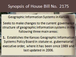
Synopsis of House Bill No.
by calandra-battersby
2175. Geographic Information Systems in Kansas. S...
GEO 241: Geographic Information Systems I
by luanne-stotts
Week 8. : . R. aster Data Model. G...
TOOLIK GIS – ANNUAL STEERING COMMITTEE MEETING:
by faustina-dinatale
January . 2. 3, 2016. Annual Toolik GIS Report. O...
CENSUS DATA For GIS Census Data
by phoebe-click
General Types:. Decennial Census (1990, 2000, 201...
Geog 301: Lecture 4 The value of spatial data
by elina
Again, portions swiped from Dr. Sterling Quinn. Wh...
GDRS and you! Geospatial Data Resource Sites
by leah
Tim Loesch, MN DNR. Presentation to the . Statewid...
Organization Spatial Data Mining Fall 2011
by claire
Introduction. Region Discovery—Finding Interesti...
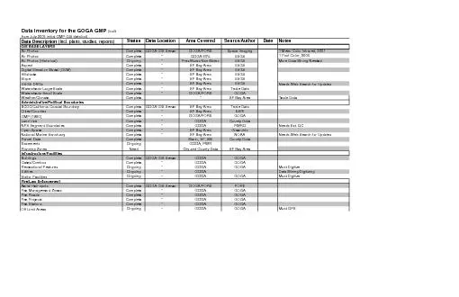
Data Inventory for the GOGA GMP
by gelbero
(built from July 2005 initial GMP GIS data list) ...
MnTOPO – A place to view, print, and download LiDAR Elevation Data
by cheryl-pisano
MnTOPO – A place to view, print, and download L...
GIS Data Collection Using
by ellena-manuel
Esri’s. . Collector App. Harkeerat Kang. 12.7....
The Memphis Economy; Using Data to Reach A New Audience
by alida-meadow
Presented by Ryan Hanson. The Sparks Bureau of Bu...
Load More...