Explore
Featured
Recent
Articles
Topics
Login
Upload
Featured
Recent
Articles
Topics
Login
Upload
Search Results for 'data dem'
data dem published presentations and documents on DocSlides.
Digital Elevation Model (DEM) Resolution and Stream
by lois-ondreau
Extraction . Using Terrain . Openness . Jos...
NSIDC
by briana-ranney
IceBridge. . Value . Added Data Products. Ted Sc...
Characterizing
by trish-goza
Underconstrained. DEM . Analysis. Mark . Weber*. ...
Using
by liane-varnes
LiDAR. , “WATER”, and TOPMODEL. TOPO-Driven H...
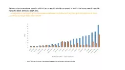
Source: Source: UN Women's calculations using data from Dem
by calandra-battersby
Source: Source: UN Women's calculations using dat...
Orange
by luanne-stotts
Topics in Machine Learning. Fall 2011. School of ...
Spatial Disaggregation – A Primer
by stefany-barnette
Tom . D’Avello. – . NRCS-NSSC-GRU. c. ontact...
Regularized
by faustina-dinatale
inversion . techniques for recovering . DEMs. Iai...
Accelerating TauDEM as a Scalable
by tatiana-dople
Hydrological Terrain Analysis Service on XSEDE. 1...
Intro to Spatial Analysis with
by luanne-stotts
What can we do with GIS?. SPATIAL STATISTICS. Wha...
C3S_312a Lot8: Glaciers
by yoshiko-marsland
Frank Paul, Michael . Zemp. Dept. of Geography, U...
Using topography to estimate flood risk
by trish-goza
Brendan Murphy. CE 397 Flood Forecasting. May 4, ...
Analyzing Inlets, Outfalls, and Land Cover Using Spatial and Network Analysis Within the San Antoni
by pasty-toler
Sewershed. Aspen Navarro, . Project Manager. , . ...
Citation: Park, J., F.
by elena
Krogstad. , J. Fridley and L. M. . Moskal, . 2009....
Open Source Tools for Treatment of
by yoshiko-marsland
Lidar. Derived Terrain Models. By Marty Earwood....
Mark Setzler, High Point University
by natalia-silvester
Religiosity and . the Success of Women . Candidat...
Precarious Work in Asia:
by pasty-toler
Data Issues and . Challenges. Joseph R. . Bongiov...
Terrain Analysis Using Digital Elevation Models (
by celsa-spraggs
TauDEM. ). Learning Objectives. To be able to del...
Using LiDAR Data to Automatically Delineate Sinkholes in So
by natalia-silvester
Nate Green and Jacob Hartle. Forest and Natural R...
Storm Tide and Flooding
by pasty-toler
from Hurricane Sandy In New York City. Xing Zheng...
Natural Neighbor Based Grid DEM Construction Using a GPU
by pasty-toler
Alex Beutel. Duke University. Joint work with . P...
Update from Australia
by lois-ondreau
A Land of Droughts and Flooding Rains. David Lemo...
3D and Surface/Terrain Analysis
by faustina-dinatale
in partnership with:. With support from:. NSF DUE...
Load More...