Explore
Featured
Recent
Articles
Topics
Login
Upload
Featured
Recent
Articles
Topics
Login
Upload
Search Results for 'arcgis data'
arcgis data published presentations and documents on DocSlides.
Geospatial Data Abstraction Library (GDAL) Enhancement for
by giovanna-bartolotta
). Increasing . Accessibility and Interoperabilit...
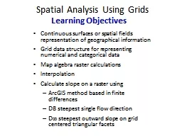
Spatial Analysis Using Grids
by giovanna-bartolotta
Continuous surfaces or spatial fields representat...
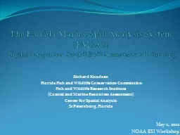
The Florida Marine Spill Analysis System (
by mitsue-stanley
FMSAS). Digital Integration . for Oil Spill Resp...
Web Services
by celsa-spraggs
National Geospatial Management Center (NGMC). Sep...
GS6384 Vault is for More than Engineers: Integrating AutoCA
by luanne-stotts
Stephen Brockwell. President, Brockwell IT Consul...
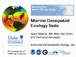
Marine Geospatial
by celsa-spraggs
Ecology Tools. Jason Roberts, Ben Best, Dan Dunn,...
ArcGIS:
by sherrill-nordquist
ArcCatalog. Agenda. The . ArcCatalog. Interface....
APDM 6.0
by debby-jeon
ArcGIS Pipeline Data Model. Peter Veenstra. APDM ...
How does a community maintain a storm
by giovanna-bartolotta
water infrastructure database in ArcGIS . 9.3 usi...
Campus Populations
by faustina-dinatale
Modeling and Visualizing the Changing . Concentra...
Aberdeen, ID Groundwater Analysis
by pasty-toler
Jerimiah Fenton. Aberdeen Wetlands. During the 19...
Grid-based Analysis in
by danika-pritchard
GIS . Prof. Yuji Murayama - Instructor. Hao. . H...
Effects of Dam-Induced Daily River Stage Fluctuations on a
by jane-oiler
Blair Stanley. November 18, 2008. Outline. Introd...
Hydrologic Application of Onion Creek
by alida-meadow
Revisit of the Halloween Flood from 2013. Juhn-Yu...
Marine Geospatial
by karlyn-bohler
Ecology Tools. Jason Roberts, Ben Best, Dan Dunn,...
Transforming Information to
by bery
Impact. with the . Living Atlas of the World. liv...
Wind and ocean Ecosystems
by fauna
April Watson and Alanna Lecher . Authors . April W...
GIS for Information Technology
by helene
Prepared by . Information . Technology Services . ...
The CUAHSI Hydrologic Information System
by riley
. Spatial Data Publication Platform. Support. EAR ...
Module - V Integration of
by liane-varnes
GIS and Remote Sensing. Analysis and Presentatio...
Assuring Connectivity in
by celsa-spraggs
an Electric Utility . GIS . Distribution . Model....
Using GIS to Analyze Movement of Tiger Sharks
by mitsue-stanley
Shark Tags. SPOT. http://www.hawaii.edu/himb/Reef...
Reported Flood Inundation due to Hurricane Harvey in Houston, TX
by alexa-scheidler
Isha Deo. November 21, 2017. Specific Issues duri...
Udvikling af Prototype til rekognoscering af feltmæssige
by danika-pritchard
landingspladser . til Hercules C130. Fra . hånds...
Exploring Arc Hydro Capabilities to Represent Water Managem
by liane-varnes
CEE . 6440 . – . GIS in Water . Resources Term ...
Part I: GIS Tools for Water Planners
by lois-ondreau
and. Part II: Sierra Nevada Conservancy . GIS Wat...
Preparing input for the TOPKAPI (
by liane-varnes
TOPographic. Kinematic Approximation and Integra...
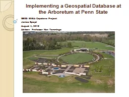
Implementing a Geospatial Database at the Arboretum at Penn State
by tawny-fly
GEOG . 596A: Capstone Project. James . Spayd. Aug...
ArcGIS: ArcMap Tables
by myesha-ticknor
Agenda. Opening tables. The interface. Working wi...
Using GIS to Compare all M&R Strategies for Asphalt Roa
by test
CEE 6240: GIS in Water Resources. By: Antonio Fue...
Roberto Lucchi
by olivia-moreira
Esri. INSPIRE Discovery, View and Download and OG...
Athenians Project TEAM Clark Yin, Eunkyung Park, Aaron Boda,
by aaron
Dr. Meng Chen, Prof. Xiaohui Yu, . Prof. Jian-Guo...
Visualizing Land Use Changes based on Historic
by tatiana-dople
I. mages of . Brevard County, Florida. Marnie . S...
Prepared by: Jennifer McKee
by karlyn-bohler
With support from:. in partnership with:. Introdu...
Craig Robinson Harnessing Configuration
by jane-oiler
for web GIS Application Development. June 4, 2014...
Prepared by: Jennifer McKee
by karlyn-bohler
With support from:. in partnership with:. Introdu...
Python Tips/Tricks
by lindy-dunigan
Python Tips/Tricks Scripting Rest Service Downlo...
An ISO 9001:2008 Registered
by freya
CMMI Maturity Level 3 Company. 1430 Spring Hill Rd...
Automatic KY guardrail detection by machine learning
by paisley
KYTC / KTC / VIS . KYTC Photo logging van. The Ken...
Hydro Networks in GIS Network model
by bery
Flow on Networks. Hydrologic networks. Linear refe...
Load More...