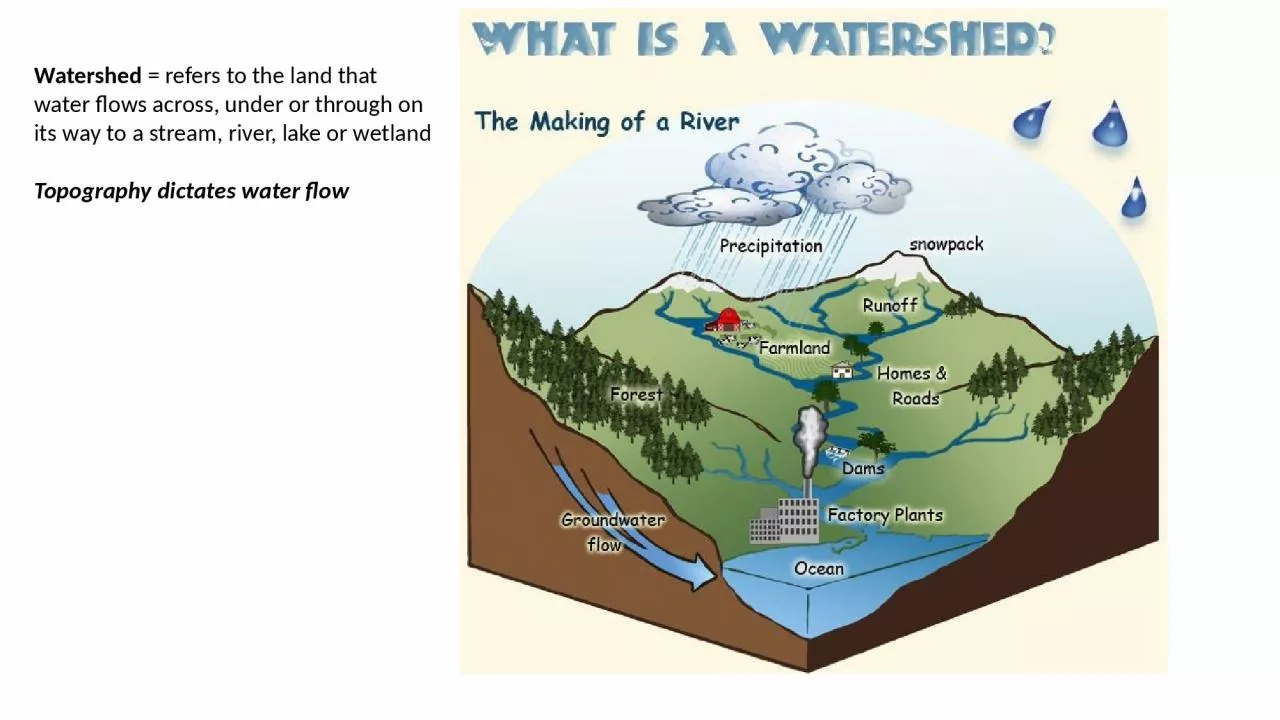
PPT-Watershed = refers to the land that water flows across, under or through on its way to
Author : pamela | Published Date : 2023-05-31
Topography dictates water flow Middle South PlatteCherry Creek Watershed httpscfpubepagovsurfhuccfmhuccode10190003 Land Use affects Water Quality Turbidity clarity
Presentation Embed Code
Download Presentation
Download Presentation The PPT/PDF document "Watershed = refers to the land that wat..." is the property of its rightful owner. Permission is granted to download and print the materials on this website for personal, non-commercial use only, and to display it on your personal computer provided you do not modify the materials and that you retain all copyright notices contained in the materials. By downloading content from our website, you accept the terms of this agreement.
Watershed = refers to the land that water flows across, under or through on its way to: Transcript
Topography dictates water flow Middle South PlatteCherry Creek Watershed httpscfpubepagovsurfhuccfmhuccode10190003 Land Use affects Water Quality Turbidity clarity pH Temperature change. Motivation. Effect of water on landscape:. Whereas hydrologists are mostly concerned with the movement of water, a common task is to assess the impact of water flow on the transport of materials – sediment and solutes. Upper . Couderay. River . Wateshed. : Including Billy Boy, . Durphee. , . Couderay. River, Grindstone, Grindstone Creek and Springs, . Gurno. , Lac Courte Oreilles, Little Courte Oreilles, Little Round, Osprey, Round, Sand, . on Soil Water and . Stream Water Chemistry. Soil Surface. H. 2. SO. 4. HNO. 3. SO. 4. 2-. + H. +. H. +. + NO. 3. -. Soil Surface. H. 2. SO. 4. HNO. 3. SO. 4. 2-. + H. +. H. +. + NO. 3. -. Exercise . 4 Overview . Online Watershed Delineation and Data Retrieval. Hydrologic Terrain Analysis. Network Analysis. The Starting Point. http://waterdata.usgs.gov/nwis/inventory?agency_code=USGS&site_no=10109000. By: Nick . Sisco. Objectives. Delineate streams and tributaries . D. elineate watersheds. Create streamlined process for future analysis. Map outfalls remotely to compare with GPS . data. Compare watershed boundaries. Harvey et al., . 1996. Two Approaches to Characterize . Hyporheic. Exchange. Hydrometric approach. Sub-reach-scale . measurement. of hydraulic heads and hydraulic conductivity to compute streambed . = area of land that drains precipitation to a body of water. 2. Depends on . topography. - Divided by ridges (hills) . drainage divides. Video. Video 2. 3. Drainage Divide. One watershed on one side of hill. Basic Approach and Resources. By . Tamatha. Patterson and Kelsey Thetonia. Indiana Watershed Leadership Academy. May 20, 2015. IMPLICATIONS OF CLIMATE CHANGE. globalchange.gov. IMPLICATIONS OF CLIMATE CHANGE. Willow Creek Demonstration Watershed, Madison Co., MT, 2006-2011. Kassia Groszewski. December . 2011. Faculty Advisor: Dr. Erika R. Elswick. Willow Creek Watershed. Garnet Mine, Oriole Adit. Tobacco Root Mountains. ATLANTA WATERSHED LEARNING NETWORK. Watershed: Implications for Healthy Water & Communities. Where . does our . water . come . from?. Georgia’s m. ain water source: rivers. Also referred to as streams. Mora River Upper Canadian PlateauPage 1Watershed Based Plan for theMora River Upper Canadian PlateauPage iiMay 6th 2016Submitted to New Mexico Environment Department NMEDFederal Clean Water Act Sectio Douglas Jackson-Smith: . SSWA Dept, USU . Nancy Mesner: . WATS Dept, USU. David Stevens, Jeff Horsburgh, Darwin Sorensen. : CEE Dept, USU. Overview. Background. Analysis of Existing WQ Data. Implementation & Maintenance Study. July 25, 2012. Flood mitigation. Water supply. Water quality. Sediment storage and transport. Habitat. Recreation. Transportation. Aesthetic qualities. What Functions do Healthy Streams Provide?. CUAHSI Virtual University. David Tarboton. Utah State University. david.tarboton@usu.edu. . Outline. A bit of a recap – the concepts involved in Thiessen Polygons. The terrain flow information model.
Download Document
Here is the link to download the presentation.
"Watershed = refers to the land that water flows across, under or through on its way to"The content belongs to its owner. You may download and print it for personal use, without modification, and keep all copyright notices. By downloading, you agree to these terms.
Related Documents